![[Earth]](../img/earth.gif)
PEM Tropics Maps
![[GTE Logo]](../img/gte_slogo.gif)
|
PEM Tropics Maps |
|
The data plots for PEM Tropics are unavailable. You may register to receive e-mail when these become available.
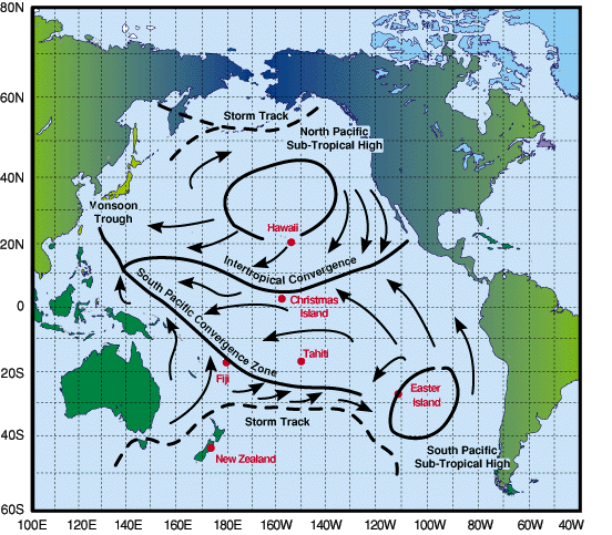
Major Features of the Atmospheric Circulation at the Surface Over the Pacific Ocean Area for June-August |
|
|
The PEM-Tropics deployment sites (Christmas Island, Tahiti, Easter Island, Guayaquil, Christchurch, and Fiji) were selected, in part, because of their relative locations to the major seasonal-mean surface meteorological features in the south central Pacific. Note that the intertropical convergence zone (ITCZ) just north of the Christmas Island and the south Pacific convergence zone (SPCZ) over Fiji are manifestations of converging air flow at the surface and lower altitudes. The PEM-Tropics flights, depicted below, were designed to permit extensive measurements in these differing air masses. (From Merrill, 1989, Atmospheric Long Range Transport to Pacific Ocean, pg. 15-50 in Chemical Oceanography, Vol. 10. Reiley and Chester, Eds Academic Press.) |

|
|
The central regions in the southern hemispherical Pacific Basin are geographically far removed from sources of pollution, yet air mass flow into this region can serve as conduits for long range transport of trace emissions from the northern hemisphere as well as from regions east and west of the tropical Pacific. As a prelude to the PEM-Tropics campaign, coordinated releases of ozone sondes were initiated from Easter Island, Tahiti, and America Samoa approximately one year prior to mission deployment. The sondes were released at a rate of one per week during the months prior to the field deployment , and increased to two per week during the deployment. During the mission deployment, the combined DC-8 and P-3B flights permitted measurements of trace gases over regions of the south Pacific that heretofore had been virtually ignored. |
[Return to the GTE
Home Page]
[Return to the PEM Tropics Flight Map]
[Feedback]