![[Earth]](../img/earth.gif)
PEM West B Maps
![[GTE Logo]](../img/gte_slogo.gif)
|
PEM West B Maps |
|
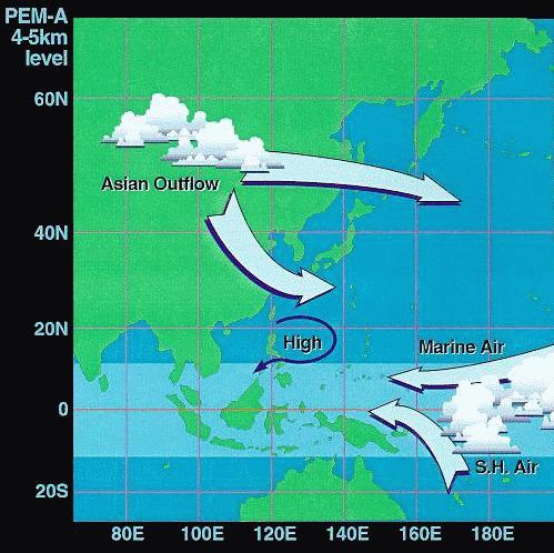
DOMINANT FLOW PATTERNS DURING PEM-WEST BStudy Period - Feb/Mar |
|
|
|
|
|
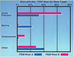
Mid-Lats |
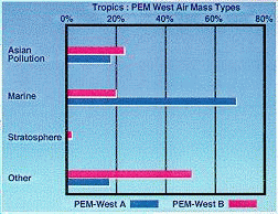
Tropics |
|
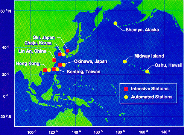
The PEM-West B study was deployed in March, 1993 to study emissions from the Asian Continent during a seasonal period characterized by maximuml outflow from the continent. Notice that in the 4 to 5 kilometer altitude region, Asian pollution is more pronounced than during the PEM-West A study period, while marine flow from the southern hemisphere was more pronounced during the PEM-West A study period. the comparison of measurements during the two study periods provide a measure of the influence of the Asian continent on the Pacific troposphere, as well as a set of baseline measurements to gauge future impacts. Ground measurements at selected sites in the Pacific provide a longer time record of emission from the Asian continent an complement the more intensive measurements provided by the instruments aboard the DC-8 aircraft. |
|
|
|
| Time History of Ground Measurements Not Available |
Measurements at the ground sites were typically filter samplers operational throughout the year. Instruments at the intensive sites generally required more frequent service and were therfore only active during the intense airborne phase of PEM-West B. Results from those measurements showing a time histroy of aerosol composition at several of these ground sites clearly show the seasonal variability of emissions from the Asian continent. |
[Return to the GTE
Home Page]
[Return to the PEM B Flight Map]
[Feedback]