| Flight Number | Start Date (GMT) | Julian Day (GMT) | Start Time(GMT) | End Time(GMT) | Flight Location and Description |
| 1P | 8/5/96 | 218 | 19:34:15 | 22:21:45 | NASA WFF Test Flight |
| 2P | 8/7/96 | 220 | 17:42:05 | 22:52:15 | NASA WFF Test Flight |
| 3P | 8/11/96 | 224 | 20:20:55 | 20:43:15 | NASA WFF Test Flight |
| 4P | 8/15/96 | 228 | 17:24:19 | 01:19:55 | NASA WFF to NASA ARC |
| 5P | 8/18/96 | 231 | 18:17:04 | 02:31:02 | NASA ARC to Hickam, HI (Stratocumulus Photochemistry) |
| 6P | 8/21/96 | 234 | 21:24:12 | 04:47:29 | Hickam, HI to Christmas, Isl. (Lat. Survey & ITCZ Grad) |
| 7P | 8/24/96 | 237 | 14:34:28 | 23:57:18 | XMAS Local (O3 Photochem. & Sulfur Oxid. Cycle) |
| 8P | 8/26/96 | 239 | 18:16:40 | 23:06:46 | Christmas Isl. to Hickam, HI (Lat. Survey of Trace Gases) |
| 9P | 8/30/96 | 243 | 03:28:59 | 07:46:05 | Hawaii Local Test Flight |
| 10P | 8/31/96 | 244 | 20:15:47 | 05:25:38 | Hickam, HI to Tahiti (Marine Upwelling & Lat. Survey) |
| 11P | 9/3/96 | 247 | 19:29:35 | 03:59:04 | Tahiti Local 1 (Marine Upwelling & Lat. Survey) |
| 12P | 9/5/96 | 249 | 19:29:11 | 03:18:13 | Tahiti Local 2 (O3 Photochem. & Lat. Survey) |
| 13P | 9/7/96 | 251 | 19:02:33 | 02:48:15 | Tahiti to Easter Isl. (Long. Survey of Trace Gases) |
| 14P | 9/10/96 | 254 | 12:36:18 | 20:13:53 | Easter Isl. Local 1 (Lat. Survey of Trace Gases) |
| 15P | 9/11/96 | 255 | 18:06:23 | 01:25:52 | Easter Isl. Local 2 (Lat. Survey of Trace Gases) |
| 16P | 9/14/96 | 258 | 14:53:05 | 23:13:33 | Easter Isl. to Guayaquil, Ecuador (Long. Survey & Continental Outflow) |
| 17P | 9/18/96 | 262 | 13:53:04 | 21:51:18 | Guayaquil Local 1 (Marine Upwelling & Continental Outflow) |
| 18P | 9/22/96 | 266 | 14:28:38 | 22:43:20 | Guayaquil Local 2 (Marine Upwelling & Continental Outflow) |
| 19P | 9/23/96 | 267 | 15:59:51 | 23:14:16 | Guayaquil Local 3 (Sulfur Oxid. Cycle & Continental Outflow) |
| 19P | 9/25/96 | 269 | 14:28:11 | 22:21:12 | Guayaquil to New Orleans (ITCZ Profile) |
| 19P | 9/26/96 | 270 | 15:01:44 | 19:02:41 | New Orleans to NASA WFF |
The PEM Tropics A data is available for all PEM Tropics A Flights, excluding Flights 1-3 & 9 (Test Flights) and Flights 11-16 (Instrument Problems) in an 18.7 hz archive file. The file, in ASCII zipped format, included the following parameters:
| Julian Day | |
| Time (# of seconds since midnight GMT) | |
| Static Pressure (mb) | |
| Static Air Temperature (K) | |
| U Wind (m/s) | |
| V Wind (m/s) | |
| W Wind (m/s) | |
| Absolute Humidity (L1011 - slow response) (g/m3) | |
| Absolute Humidity (Lyman Alpha - fast response) (g/m3) | |
| Equivalent Potential Temperature (K) |
The data is available thru the GTE Project Office or by e-mailing a request to Lee Thornhill
A single day of flights in the vicinity of Christmas Island provided the basis for a study of the transport properties of this Tropical marine boundary layer. The flight plan during Flight 7 consisted of a series of 30-minute circles at three heights in the mixed layer (77 m, 160 m, and 310 m), along with vertical soundings. The turbulent transport across the mixed layer (about 600 m deep) was heavily influenced by mesoscale processes. Further, the mesoscale component of the vertical transport of momentum and water vapor changed significantly with height above the surface, so that the vertical flux divergence is strongly affected by mesoscale variability. The results suggest that mesoscale processes have a large impact on the rate of entrainment into the mixed layer. The findings represent a single day's data, but they suggest that mesoscale variability strongly modulates the exchange of momentum and moisture between the surface and the free troposphere. Since bulk transfer equations for computing turbulent tend not to perform well in environments where mesoscale processes play a large role, our results support the need for application of improved bulk aerodynamic equations such as proposed by Mahrt and Sun (Monthly Weather Review, 123, 3032-3041).
A notable feature of the turbulent transport is that the surface humidity flux remained relatively constant throughout the 8 hour period of the flights, whereas the flux at 300 m, half way through the mixed layer, increased by 50%. This increase coincided with an increase in the dynamical scales associated with the fluxes. If the increase in the fluxes were simply due to a larger source or sink of moisture, with no change in the dynamics, the distribution of scales in the co-spectra would remain constant. The change in the characteristic dynamical scales in the co-spectra is highly correlated with the flux, suggesting that changing dynamical processes are what cause the increases in the flux.
We also examined the effects of using an alternative scale decomposition for filtering and analysis of scale in the turbulence data. Some work has been done comparing the decomposition of scales using Fourier transforms with moving averages (Howell and Mahrt, 1997; Sun et al., 1996). The moving average (MA) technique (described in detail with software to compute it below) uses a localized non-orthogonal basis to determine the fraction of variance and covariance associated with different dynamical scales. Fourier modes are not localized in physical space (they have no edges), so there is reason to examine the extent to which a localized basis set (moving averages in this case) yield a different distribution of scales. Since the decomposition of turbulence also is used to remove the largest scales of variability that are unreliably resolved because of our finite sampling scale, we have examined the effect on fluxes when we use the MA vs. Fourier approaches. We find differences of up to 6% of the latent heat between the Fourier and MA derived fluxes.
For a discussion of these results, please contact G. Considine for a copy of a paper that is currently in the review process at The Journal of Geophysical Research.
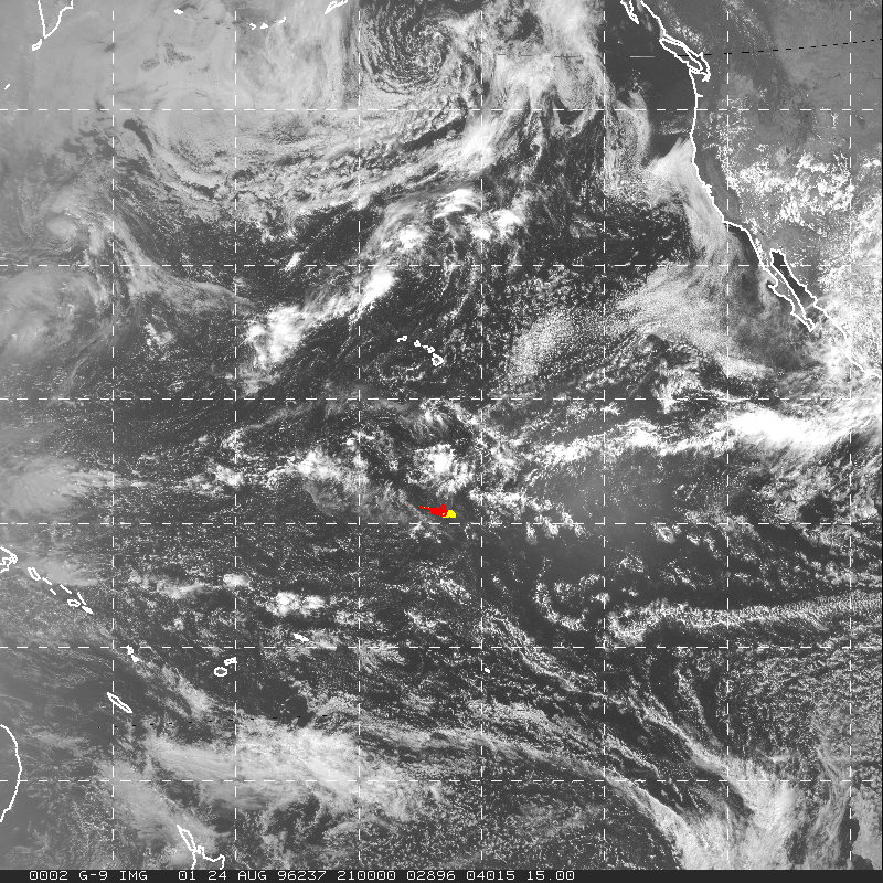
A cursory look at satellite imagery from GOES 9 satellite suggests the presence of clouds on a wide range of scales (bright in VIS and cold in IR). The images below are 15 degrees by 15 degrees. Don Lenschow and collaborators have analyzed this day's flights and found evidence that cumulus convection appears to be measurably affecting the transport features of the boundary layer.
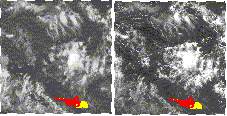
IR Image and the VIS Image
Imagery from GOES 9. Yellow and red mark flight track during Xmas Island. These images are fairly degraded, but the full images are available from the GTE web page:
This was a quasi-Lagrangian flight, with the pilots following predominant winds over the course of the mission. The main maneuvers performed were 30-minute circles, referred to as flux circles, or FC's. Note that FC's 2, 5, and 10, had 5 minute legs alternating between altitudes.
Local Time = GMT - 10 hours
| Time (GMT) | Description of Activity |
| 14:30 | Take off from Xmas Island |
| 14:41:40 | @4000 ft, straight and level |
| 15:26:45 | End leg @4000 ft, start climb to 6000 ft |
| 15:29 | @6000 ft, descend to 1000 ft |
| 15:35:43 | @1000 ft begin FC 1 |
| 16:05 | @ 1000 ft end FC 1 |
| 16:10:50 | Cloud base of fair weather cumulus clouds @ 1500 ft, coverage approximately 20%. Begin 5-minute leg of FC 2 |
| 16:16 | Ascend to 2000 ft |
| 16:18:30 | @ 2000 ft, broken cloud deck at this altitude |
| 16:25 | Ascend to 2500 ft |
| 16:26:40 | @ 2500 ft |
| 16:31:55 | Descend to 200 ft |
| 16:35 | @ 2000 ft |
| 16:40:10 | End FC 2, descend to 500 ft |
| 16:46 | @500 ft begin FC 3 |
| 17:16 | End FC 3, descend to 250 ft |
| 17:21 | @250 ft begin FC 4 |
| 17:51:10 | End FC4, Ascend to 2000 ft |
| 17:56 | Scattered clouds @ 2000 ft |
| 17:57:20 | @ 2000 ft begin 5 minute leg |
| 18:02:20 | Ascend to 3000 ft |
| 18:05:30 | @ 3000 ft, 5 minute horizontal leg |
| 18:10:30 | Descend to 2000 ft |
| 18:13:15 | @ 200 ft 5 minute leg |
| 18:19:10 | Ascend to 3000 ft |
| 18:21 | @ 3000 ft above most clods, still fair weather cumulus but increasing coverage to <= 40% |
| 18:26:45 | Descend to 1000 ft, passed through clouds |
| 18:31:45 | @ 1000 ft begin FC 6 |
| 19:01:30 | End FC 6, descend to 250 ft |
| 19:05:15 | @ 250 ft being FC 7 |
| 19:35:15 | Ascend to 16000 ft, scattered cumulus clouds |
| 19:51:30 | @ 1600 ft, circle |
| 20:12 | Descend from 16000 ft to 15500 ft |
| 20:21:45 | Begin spiral down to 500 ft. Descent rate at 1000 ft / minute |
| 20:36:45 | Cloud tops at 3000-5000 ft, cloud bases at about 1500-1800 ft |
| 20:40:45 | @500 ft begin FC 8. Quite clear, few clouds |
| 21:10:50 | @500 ft end FC8 and start ascent to 1000 ft |
| 21:15 | @1000 ft begin FC 9 |
| 21:28 | Increasing cloud cover to <= 30-40% |
| 21:45:15 | Ascend to 2000 ft |
| 21:49:45 | @ 2000 ft begin FC 10 with 5 minute leg. Cloud deck at about 2000 ft |
| 21:54:45 | Ascend from 2000 ft to 3000 ft |
| 21:56:25 | @ 3000 ft 5 minute horizontal leg |
| 21:58:28 | Penetrate clouds briefly |
| 22:01:30 | Descend to 2000 ft |
| 22:03:55 | @ 2000 ft 5 minute horizontal leg |
| 22:09:00 | Ascend to 3000 ft |
| 22:10:50 | @ 3000 ft 5 minute leg |
| 22:16:10 | Descend to 2000 ft |
| 22:18 | 2 minute horizontal leg @ 2000 ft |
| 22:20 | End FC 10. Descend to 500 ft |
| 22:24:15 | @ 500 ft begin FC 11 |
| 22:54:15 | End FC 11. Descend to 250 ft |
| 22:58:35 | @ 250 ft begin FC 12 |
| 23:28:40 | End FC 12. Ascend to 1000 ft en route back to Xmas Island |
![]()
Responsible NASA Official(TAMMS): Bruce
Anderson
Curator(TAMMS): Lee Thornhill