![[Earth]](../img/earth.gif) |
PEM West A Flights |
![[GTE Logo]](../img/gte_slogo.gif) |
Select the flight number above to see the data plots for that flight.
Key: (na) = Not available.
Return to the GTE Field Missions.
Return to the GTE World Map
A summary of the PEM West A mission
explains the reason for the mission, the methods used to gather data,
and a synopsis of the results.
Results of PEM West A.
More maps for PEM West A are available
containing airflow drawing and a chart of ground based measurement
locations.
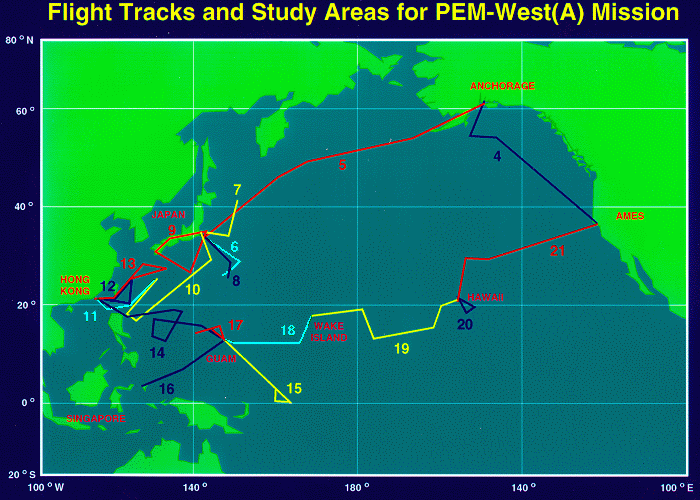
Flight #4
Purpose: Survey and ferryLocation: Ames to Anchorage
Date: Sept. 16, 1991
Plots:
- 01 - Map and Time series plots of alt, temp, humidity, and theta
- 02 - Time series plots of O3, CO2(na), Methane, N2O(na), and Benzene
- 03 - Time series plots of NO, NOx(na), NOy, PAN, and Nitric Acid
- 04 - Time series plots of Acetylene, Ethane, Propane, C2C14, and CH3CC13
- 05 - Time series plots of SO2, DMS, Ethylene, H2O2, and CH3OOH
- 06 - Altitude vs. Temp, Dewpoint, Ozone, CO, Methane (1715 and 1930 GMT)
- 07 - Altitude vs. Temp, Dewpoint, Ozone, CO, Methane (2130 GMT)
Flight #5
Purpose: Survey and ferryLocation: Anchorage to Yokota
Date: Sept. 17-18, 1991 (crossed international date line)
Plots:
- 01 - Map and Time series plots of alt, temp, humidity, and theta
- 02 - Time series plots of O3, CO2(na), Methane, N2O(na), and Benzene
- 03 - Time series plots of NO, NOx(na), NOy, PAN, and Nitric Acid
- 04 - Time series plots of Acetylene, Ethane, Propane, C2C14, and CH3CC13
- 05 - Time series plots of SO2, DMS, Ethylene, H2O2, and CH3OOH
- 06 - Altitude vs. Temp, Dewpoint, Ozone, CO, Methane (1900 and 2215 GMT)
- 07 - Altitude vs. Temp, Dewpoint, Ozone, CO, Methane (0300 GMT)
Flight #6
Purpose: Background marine airLocation: Yokota to Yokota
Date: Sept. 22, 1991
Plots:
- 01 - Map and Time series plots of alt, temp, humidity, and theta
- 02 - Time series plots of O3, CO2, Methane, N2O(na), and Benzene
- 03 - Time series plots of NO, NOx, NOy, PAN, and Nitric Acid
- 04 - Time series plots of Acetylene, Ethane, Propane, C2C14, and CH3CC13
- 05 - Time series plots of SO2, DMS, Ethylene, H2O2, and CH3OOH
- 06 - Altitude vs. Temp, Dewpoint, Ozone, CO, Methane (0415 and 0830 GMT)
Flight #7
Purpose: Continental outflowLocation: Yokota to Yokota
Date: Sept. 24, 1991
Plots:
- 01 - Map and Time series plots of alt, temp, humidity, and theta
- 02 - Time series plots of O3, CO2, Methane, N2O, and Benzene
- 03 - Time series plots of NO, NOx, NOy, PAN, and Nitric Acid
- 04 - Time series plots of Acetylene, Ethane, Propane, C2C14, and CH3CC13
- 05 - Time series plots of SO2, DMS, Ethylene, H2O2, and CH3OOH
- 06 - Altitude vs. Temp, Dewpoint, Ozone, CO, Methane (0300 and 0815 GMT)
Flight #8
Purpose: Diurnal photochemistryLocation: Yokota to Yokota
Date: Sept. 25-26, 1991
Plots:
- 01 - Map and Time series plots of alt, temp, humidity, and theta
- 02 - Time series plots of O3, CO2, Methane, N2O, and Benzene
- 03 - Time series plots of NO, NOx, NOy, PAN, and Nitric Acid
- 04 - Time series plots of Acetylene, Ethane, Propane, C2C14, and CH3CC13
- 05 - Time series plots of SO2, DMS, Ethylene, H2O2, and CH3OOH
- 06 - Altitude vs. Temp, Dewpoint, Ozone, CO, Methane (1930 and 2200 GMT)
Flight #9
Purpose: Typhoon MireilleLocation: Yokota to Yokota
Date: Sept. 27, 1991
Plots:
- 01 - Map and Time series plots of alt, temp, humidity, and theta
- 02 - Time series plots of O3, CO2, Methane, N2O, and Benzene
- 03 - Time series plots of NO, NOx, NOy, PAN, and Nitric Acid
- 04 - Time series plots of Acetylene, Ethane, Propane, C2C14, and CH3CC13
- 05 - Time series plots of SO2, DMS, Ethylene, H2O2, and CH3OOH
- 06 - Altitude vs. Temp, Dewpoint, Ozone, CO, Methane (0400 and 0730 GMT)
Flight #10
Purpose: Survey and ferryLocation: Yokota to Okinawa
Date: Oct. 1, 1991
Plots:
- 01 - Map and Time series plots of alt, temp, humidity, and theta
- 02 - Time series plots of O3, CO2, Methane, N2O, and Benzene
- 03 - Time series plots of NO, NOx, NOy, PAN, and Nitric Acid
- 04 - Time series plots of Acetylene, Ethane, Propane, C2C14, and CH3CC13
- 05 - Time series plots of SO2, DMS, Ethylene, H2O2, and CH3OOH
- 06 - Altitude vs. Temp, Dewpoint, Ozone, CO, Methane (0300 and 0700 GMT)
- 07 - Altitude vs. Temp, Dewpoint, Ozone, CO, Methane (0915 GMT)
Flight #11
Purpose: Survey and ferryLocation: Okinawa to Hong Kong
Date: Oct. 2, 1991
Plots:
- 01 - Map and Time series plots of alt, temp, humidity, and theta
- 02 - Time series plots of O3, CO2, Methane, N2O, and Benzene
- 03 - Time series plots of NO, NOx, NOy, PAN, and Nitric Acid
- 04 - Time series plots of Acetylene, Ethane, Propane, C2C14, and CH3CC13
- 05 - Time series plots of SO2, DMS(na), Ethylene, H2O2, and CH3OOH
- 06 - Altitude vs. Temp, Dewpoint, Ozone, CO, Methane (0015 and 0215 GMT)
Flight #12
Purpose: Continental outflow and Tiwan flybyLocation: Hong Kong to Hong Kong
Date: Oct. 4, 1991
Plots:
- 01 - Map and Time series plots of alt, temp, humidity, and theta
- 02 - Time series plots of O3, CO2, Methane, N2O, and Benzene
- 03 - Time series plots of NO, NOx, NOy, PAN, and Nitric Acid
- 04 - Time series plots of Acetylene, Ethane, Propane, C2C14, and CH3CC13
- 05 - Time series plots of SO2, DMS, Ethylene, H2O2, and CH3OOH
- 06 - Altitude vs. Temp, Dewpoint, Ozone, CO, Methane (0900 GMT)
Flight #13
Purpose: Continental outflowLocation: Hong Kong to Hong Kong
Date: Oct. 6, 1991
Plots:
- 01 - Map and Time series plots of alt, temp, humidity, and theta
- 02 - Time series plots of O3, CO2, Methane, N2O, and Benzene
- 03 - Time series plots of NO, NOx, NOy, PAN, and Nitric Acid
- 04 - Time series plots of Acetylene, Ethane, Propane, C2C14, and CH3CC13
- 05 - Time series plots of SO2, DMS, Ethylene, H2O2, and CH3OOH
- 06 - Altitude vs. Temp, Dewpoint, Ozone, CO, Methane (0445 and 0645 GMT)
Flight #14
Purpose: Survey and ferry, typhoon OrchidLocation: Hong Kong to Guam
Date: Oct. 8, 1991
Plots:
- 01 - Map and Time series plots of alt, temp, humidity, and theta
- 02 - Time series plots of O3, CO2, Methane, N2O, and Benzene
- 03 - Time series plots of NO, NOx, NOy, PAN, and Nitric Acid
- 04 - Time series plots of Acetylene, Ethane, Propane, C2C14, and CH3CC13
- 05 - Time series plots of SO2, DMS, Ethylene, H2O2, and CH3OOH
- 06 - Altitude vs. Temp, Dewpoint, Ozone, CO, Methane (0200 and 0700 GMT)
- 07 - Altitude vs. Temp, Dewpoint, Ozone, CO, Methane (0945 GMT)
Flight #15
Purpose: Marine, southeast of GuamLocation: Guam to Guam
Date: Oct. 11-12, 1991
Plots:
- 01 - Map and Time series plots of alt, temp, humidity, and theta
- 02 - Time series plots of O3, CO2, Methane, N2O, and Benzene
- 03 - Time series plots of NO, NOx, NOy, PAN, and Nitric Acid
- 04 - Time series plots of Acetylene, Ethane, Propane, C2C14, and CH3CC13
- 05 - Time series plots of SO2, DMS, Ethylene, H2O2, and CH3OOH
- 06 - Altitude vs. Temp, Dewpoint, Ozone, CO, Methane (0315 and 0715 GMT)
Flight #16
Purpose: Marine, southeast of GuamLocation: Guam to Guam
Date: Oct. 13, 1991
Plots:
- 01 - Map and Time series plots of alt, temp, humidity, and theta
- 02 - Time series plots of O3, CO2, Methane, N2O, and Benzene
- 03 - Time series plots of NO, NOx, NOy, PAN, and Nitric Acid
- 04 - Time series plots of Acetylene, Ethane, Propane, C2C14, and CH3CC13
- 05 - Time series plots of SO2, DMS, Ethylene, H2O2, and CH3OOH
- 06 - Altitude vs. Temp, Dewpoint, Ozone, CO, Methane (0400 and 0800 GMT)
Flight #17
Purpose: Diurnal photochemistry, west of GuamLocation: Guam to Guam
Date: Oct. 14-15, 1991
Plots:
- 01 - Map and Time series plots of alt, temp, humidity, and theta
- 02 - Time series plots of O3, CO2, Methane, N2O, and Benzene
- 03 - Time series plots of NO, NOx, NOy, PAN, and Nitric Acid
- 04 - Time series plots of Acetylene, Ethane, Propane, C2C14, and CH3CC13
- 05 - Time series plots of SO2, DMS, Ethylene, H2O2, and CH3OOH
- 06 - Altitude vs. Temp, Dewpoint, Ozone, CO, Methane (2015 and 2300 GMT)
- 07 - Altitude vs. Temp, Dewpoint, Ozone, CO, Methane (0200 GMT)
Flight #18
Purpose: Survey and ferryLocation: Guam to Wake Island
Date: Oct. 17-18, 1991
Plots:
- 01 - Map and Time series plots of alt, temp, humidity, and theta
- 02 - Time series plots of O3, CO2, Methane, N2O, and Benzene
- 03 - Time series plots of NO, NOx, NOy, PAN, and Nitric Acid(na)
- 04 - Time series plots of Acetylene, Ethane, Propane, C2C14, and CH3CC13
- 05 - Time series plots of SO2, DMS, Ethylene, H2O2, and CH3OOH
- 06 - Altitude vs. Temp, Dewpoint, Ozone, CO, Methane (0115 and 0230 GMT)
- 07 - Altitude vs. Temp, Dewpoint, Ozone, CO, Methane (0330 GMT)
Flight #19
Purpose: Survey and ferryLocation: Wake Island to Hawaii
Date: Oct. 18-19, 1991 (crossed international date line)
Plots:
- 01 - Map and Time series plots of alt, temp, humidity, and theta
- 02 - Time series plots of O3, CO2, Methane, N2O, and Benzene
- 03 - Time series plots of NO, NOx, NOy, PAN, and Nitric Acid
- 04 - Time series plots of Acetylene, Ethane, Propane, C2C14, and CH3CC13
- 05 - Time series plots of SO2, DMS, Ethylene, H2O2, and CH3OOH
- 06 - Altitude vs. Temp, Dewpoint, Ozone, CO, Methane (0100 and 0315 GMT)
Flight #20
Purpose: Intercomparison with Mauna Loa Observatory ground measurementsLocation: Hawaii to Hawaii
Date: Oct. 20, 1991
Plots:
- 01 - Map and Time series plots of alt, temp, humidity, and theta
- 02 - Time series plots of O3, CO2, Methane, N2O, and Benzene
- 03 - Time series plots of NO, NOx, NOy, PAN, and Nitric Acid
- 04 - Time series plots of Acetylene, Ethane, Propane, C2C14, and CH3CC13
- 05 - Time series plots of SO2, DMS, Ethylene, H2O2, and CH3OOH
- 06 - Altitude vs. Temp, Dewpoint, Ozone, CO, Methane (1545 GMT)
Flight #21
Purpose: Survey and ferryLocation: Hawaii to Ames
Date: Oct. 21, 1991
Plots:
- 01 - Map and Time series plots of alt, temp, humidity, and theta
- 02 - Time series plots of O3, CO2, Methane, N2O, and Benzene
- 03 - Time series plots of NO, NOx, NOy, PAN, and Nitric Acid
- 04 - Time series plots of Acetylene, Ethane, Propane, C2C14, and CH3CC13
- 05 - Time series plots of SO2, DMS, Ethylene, H2O2, and CH3OOH
- 06 - Altitude vs. Temp, Dewpoint, Ozone, CO, Methane (1930 GMT)
[Return to the GTE Home Page]
[Return to the GTE Field Missions]
[Return to the GTE World Map]
[Feedback]